
User:Jules/graduationproposal: Difference between revisions
| (46 intermediate revisions by the same user not shown) | |||
| Line 1: | Line 1: | ||
== ''''' <span style="color:white;background-color:blue"> | == ''''' <span style="color:white;background-color:blue">Untitled</span> ''''' == | ||
<div style="width:60%"> | <div style="width:60%"> | ||
== <span style="background-color:yellow">Introduction</span>== | |||
[[File:Oppenheim transplant 1.jpg| | For my graduation project I want to draw constellation shapes from the sky over the world using connected devices for stars. To create the shapes I would use the IP addresses of the devices, on the basis of their geographical coordinates. Formally, this project was inspired by the Gallery Transplants made by Dennis Oppenheim in 1969. A Gallery Transplant consists in a transfer from the enclosed architectural and cultural space of the museum to an open exterior space. He applied the process to the Andrew Dickson White Museum and the Stedelijk Museum transferred respectively to the campus grounds of Cornwell University and Jersey city. | ||
[[File:OppenheimStedelijkJersey.jpg| | |||
[[File:Oppenheim transplant 1.jpg|300px]] | |||
[[File:OppenheimStedelijkJersey.jpg|300px]] | |||
<small> <br /> | <small> <br /> | ||
''The plan of the galley's floor is drawn outside in the snow. The result is then presented with an official plan of the Gallery, a topographic map and a picture of the installation.''</small> <br /> <br /> | ''The plan of the galley's floor is drawn outside in the snow. The result is then presented with an official plan of the Gallery, a topographic map and a picture of the installation.''</small> <br /> <br /> | ||
Robert Smithson | Robert Smithson talked about ''“Dis-location”''to qualify Oppenheim's process. To him Oppenheim operated in a Data transfer from a part of the world to another.<ref> | ||
(1)Lisa Bear et Willoughby Sharp, "Discussions with Heizer, Oppenheim, Smithson (1970)", In : Robert Smithson : The Collected Writings, Berkeley, Los Angeles, London, University of California Press, 1996, p. 244.</ref> | (1)Lisa Bear et Willoughby Sharp, "Discussions with Heizer, Oppenheim, Smithson (1970)", In : Robert Smithson : The Collected Writings, Berkeley, Los Angeles, London, University of California Press, 1996, p. 244.</ref> | ||
My drawings would be vulnerable, because of the rapid changes over the network. Nevertheless, I will have produce documents through its realisation. These would support my progress with the process but can also prove the conceptual existence of the work. A form of documentation would constitute the project's final outcome, since no one would be able to go on site anyway. | |||
Thinking about the sun tunnels of Nancy Holt made me | Thinking about the sun tunnels of Nancy Holt made me decide to go for star constellations. As an apparatus, the Sun Tunnels enables the connection between the two milieus by transferring information from one to the other. It also brings the sky down to human scale. | ||
[[File:Suntunnels.jpg| | [[File:Suntunnels.jpg|500px]] | ||
''"It’s an inversion of the sky/ground relationship-bringing the sky down to the earth."'' | <sup>''"It’s an inversion of the sky/ground relationship-bringing the sky down to the earth."''</sup> | ||
Although it started for me as a formal analogy with computer network topologies<ref>https://pzwiki.wdka.nl/mediadesign/User:Jules/linkingdots</ref>, the idea kept on growing around the actual creation and use of constellations to guide human activity on Earth. | |||
==Relation to previous practice== | == <span style="background-color:yellow">Relation to previous practice</span>== | ||
My | My practice revolves around the process of mapping and revealing invisible processes through digital means. I also feel in a constant personal reevaluation of the difficult relationship between systems for mapping and the reality of the objects being mapped. Having a reflexive approach to the tools is important to me because visualisations have the power to determine our relationship to our close and distant environment. Nevertheless they only constitute fragments of reality. Another important thing about my work is that I never really consider my projects as formally set. They can be reactivated through different formats. | ||
=== 1. Browsed landscapes <ref>http://pzwiki.wdka.nl/mediadesign/User:Jules/browsedlandscapes</ref> === | === 1. Browsed landscapes <ref>http://pzwiki.wdka.nl/mediadesign/User:Jules/browsedlandscapes</ref> === | ||
Browsed landscapes consists in a series of three projects like variations of the same process The different applications of the same operation can generate different highlights over the question of the place when it comes to the Internet's infrastructure outputs. The investigation was pursued over the Network with the tools I could find. | Browsed landscapes consists in a series of three projects like variations of the same process. The different applications of the same operation can generate different highlights over the question of the place when it comes to the Internet's infrastructure outputs. The investigation was pursued over the Network with the tools I could find. The geographical coordinates were found through a free IP Geolocation database (MaxMind) and the images come from a geolocating image sharing website (Panoramio). At the time, I realised a few things, such as the fact that I mainly browse in the U.S.A, but also that GeoIP databases were constituted in an obscure way. Their reliability is not quite perfect. | ||
<gallery mode=packed> | <gallery mode=packed> | ||
File:Gfi-02.JPG | File:Gfi-02.JPG | ||
| Line 95: | Line 95: | ||
[[File:Sheet04.png |200px]] | [[File:Sheet04.png |200px]] | ||
==Thesis intention | ==<span style="background-color:yellow">Thesis intention</span>== | ||
I would like the thesis to reflect on my process. Making an installation within a networked environment necessitates to be mediated by means for spatial representation. Since the tools for mediation plays a major part within the work, I will reflect on their implications and functioning | I would like the thesis to reflect on my process. Making an installation within a networked environment necessitates to be mediated by means for spatial representation. Since the tools for mediation plays a major part within the work, I will reflect on their implications and functioning. I think it will be also important to define to which extent, how and why things can be physically located through digital networks. The spatial properties of the Internet determine our relation to society. They define what it means to inhabit Earth in the era of ubiquitous computer networks. The context part is already underlining a few notions I am interested in. | ||
==Context== | ==<span style="background-color:yellow">Context</span>== | ||
''“Our culture is undergoing a truly drastic change in terms of our physical and psychological relationship with space and other bodies.”'' <br /> | |||
<small>-Machiko Kusahara</small> <ref> “Presence, Absence, and Knowledge in Telerobotic Art,” in The Robot in the Garden, 2000</ref> | |||
=== | ===1. Entropy=== | ||
[[File:Deserttumblr.png|thumbnail|right|200px|<small>http://desert.fail/ure/ by Guido Segni, 2015 is meant for a duration of 50 years but most chances are that the artwork will break down before its due date.</small>]] | |||
''"The future is but the obsolete in reverse"''<br /> | |||
<small>-Vladimir Nabokov</small> <ref>"Lance", 1952</ref> | |||
''[…] it's (entropy) a condition that's irreversible, it's condition that's moving towards a gradual equilibrium and it's suggested in many ways.'' <br /> | |||
<small>-Robert Smithson</small><ref>"Entropy made visible", 1973</ref> | |||
'' | Following the logic described by Smithson's drawings about the Earth works, my site installation will perish, because of changes in the network. This equilibrium mentioned by Smithson is nested within the continuity experienced by users while browsing experience of the Internet, as discussed by Alexander R. Galloway.<ref>"Protocols or how control exists after decentralization", 2004, p 68 <br /> | ||
''“All technology is new technology. Everything else must be eliminated. Dead media are those media that have fallen out of use. They include everything from dead hardware (Commodore 64, Apple II) to dead computer languages (Fortran, Cobol) to dead media formats (Sony Betamax, 8-track cassette). Dead media means discontinuity. Dead media do not function within contemporary network flows; therefore, they have no place.”''</ref> Continuity is enhanced through a strict set of rules, contributing to erase any trace of obsolescence from the user's experience (link rot, obsolete machines, etc). The failure to maintain the work on a long time scale can reveal the rapid changes in agencies within digital networks. It is also an act of resistance against the sensation of smooth continuity enhanced by protocols. This notion is also present in the recently unveiled A quiet desert failure<ref>http://desert.fail/ure/</ref> by Guido Segni which automates the transfer of Google's satellite images from the Sahara desert to Tumblr's data servers. The page mentions that ''“The whole performance will approximately take 50 years to be completed, but it is still not clear if the audience, the Google’s servers, the Tumblr archive or the Internet itself will last enough to see the end.”'' | |||
Drawing a static shape over the Internet would constitute an event that will become quickly impossible to reenact. The reasons for its failure are nested within the administration of such space. | |||
===2. Contexts of appearance=== | |||
[[File:Sitenonsite.png|thumbnail|right|300px|<small>Dialectic of Site and Non-site according to Robert Smithson</small><small>Small text</small>]] | |||
''"Instead of putting something on the landscape, I decided it would be interesting to transfer the land indoors, to the Non-site, which is an abstract container."'' <br /> | |||
<small>-Robert Smithson</small> <ref>(Kasther and Wallis, 1998: 31)</ref> | |||
Since the installation is happening within the Internet's invisible infrastructure ( a network of digital networks), the work has to manifest within another format than its actual site. I will need to find a way to translate of the spatial dimension of the piece. The margin for variability that I like to allow within my projects is something that makes me relate a lot to Robert Smithson. In the case of ''Spiral Jetty'' (1970) for instance, Smithson considered that the work had three manifestations under the same name, and that each of them constitutes a work in its own right. Those consist in the outdoor installation at Rozel point in the Great Salt Lake (Utah)<ref>http://www.robertsmithson.com/earthworks/spiral_jetty.htm</ref>, the film<ref>https://www.youtube.com/watch?v=vCfm95GyZt4</ref> and an essay<ref>The Spiral Jetty, 1970, published in Robert Smithson: The Collected Writings, edited by Nancy Holt, New York University Press, pp. 109-113</ref>. To Smithson, the sculpture was occupying a Site, while the film and the essay constituted non-sites. Language (the essay), photographic images (the film), and earth (the jetty) were considered by Smithson as materials of equal values. This approach is certainly informed by the aforementioned notions of entropy but also due to the intentions behind the site intervention. The work is processual, on an environmental scale , and in a remote location. The idea of the piece has to manifest in a shape that is appropriate to the context in which it is being communicated about. The different formats used can contrast with each other in terms of their capacity to endure time and space. Similarly, a digital network intervention can re-manifest itself within different strategies to communicate about its intentions. Moreover, my work cannot be experienced at all, so the only proof that the configuration I will show exist will be visible within the documents. | |||
=== | ===3. Inhabiting maps=== | ||
[[File:Thumb.jpg|thumbnail|right|200px|<small>In 1969, John Baldessari took a map of California and went to each place on the map where the map letters spelling ‘California’ would be located. At these sites, he spelled out the letter in any way he could and took a picture.</small>]] | |||
' | Relating IP addresses over the Network with Earth's physical position means that I have to deal with the geographic coordinates system. This system needs knowledge of geographic cartography for decoding, since they are in a dialogue (plotted map and attributed points). It will be a necessary evil/interface for me. Geert Lovink says that ''“Richard Rogers suggests that mapping networks, especially as an intelligence task, carries with it more than just an aesthetic outcome; we are in the midst of a techno-pistemological impulse in which the form(at) of the map has a structuring effect on how we understand the organisation (structure) and dynamics (movement) of networks (2003).”'' I think that this does not apply to networks only, but to the old tradition of geographic cartography as well, although mapping digital networks has a shorter history. People have an impression of the rest of the world that they acquired through maps. If I didn't go around the world with a mental idea of the European frontiers, within which France happens to be located, I would never be able to identify myself as a European person. Ideological content gets assigned to places through maps as they create spatial relations between groups of populations. We inhabit them as a result. As Martin Dodge puts it: ''All world maps are semiotically frontier signs, on the ground, the frontier line is not physically traceable yet maps have a performative action in the construction of territory'' | ||
All maps are untrue by essence, because they cannot represent all the things of the world (unless they were on the scale of a mile for a mile <ref>"On the exactitude in sciences" Jorge Luis Borges, 1946</ref>). Nevertheless, I think that the physical and the digital should be associated in spatial representations, since their association constitutes the social environment. I am not sure yet if I would restrain myself to the typical Mercator projection for the outcome of the project, but I will certainly need it through the process. The plotting on such model draws from the “known” and goes beyond. Doing so can provoke positive responses<ref>''"Seeing the entire exhibition takes all of 30 seconds if you click quickly, but it will inevitably leave your perspective changed. Because even though we all know that the Internet spans the world, our browsers render it as an experience all of 13 inches wide on a laptop screen, with no image, video, or article more than a few keystrokes or clicks away. Our feedback for this exploration is wholly positive in nature—we’re constantly rewarded with content at no real cost, like children who understand the concept of money but have absolutely no concern as to how their parents make it."'' Mark Wilson<br /> http://www.fastcodesign.com/1671946/see-where-websites-live </ref> like the ones provoked by Silvio Larusso's ''Data Centre Grand Tour''<ref>https://www.youtube.com/watch?v=3YSWXHUAG4A</ref>. Also, since I am not trying to reveal any type of truth about networks behaviour, I hope that I can at least show that any story can be told when it comes to mapping. | |||
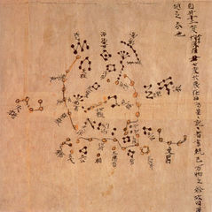
===4. Finding patterns in the Sky=== | |||
Finding patterns in the sky has been a long-going practice in the history of human civilizations. Drawing shapes with stars has enabled people to have a stable geolocating system in relation to which they could navigate, cultivate food, keep track of time and support mythological belief (religion, astrology etc). Discovered in 2004, a structure called the ''Temple of Fox'' (2000BC), in Buena Vista (Peru) has established the use of constellations and astronomy by the Andeans as a guide for agriculture.<ref>http://phys.org/news/2006-05-oldest-art-agriculture-calendar-world.html#jCp </ref> The urban planing of the Mayan cities, the orientation of the Giza pyramids in Egypt or the traditional Polynesian navigation methods<ref>https://en.wikipedia.org/wiki/Polynesian_navigation</ref> are other examples (out of many) which establish the use of stars to define systems for positioning. In a much less distant past, celestial navigation was used extensively in aviation and marine navigation. Due to the fear of G.P.S system hacking, the U.S army has decided this year to return to this method. It has eventually stopped being part of the training about two decades ago. <ref>http://www.military.com/daily-news/2015/10/14/celestial-navigation-returns-to-naval-academy.html </ref> This method shows many advantages, also for the military purposes : it can be used independently of ground aids, it has global coverage, it cannot be jammed (only clouds can be a problem) and does not give off any signals that could be detected by an enemy. | |||
== | <gallery mode=packed-hover heights="160px"> | ||
File:Lascaux.jpeg|[[http://news.bbc.co.uk/2/hi/science/nature/871930.stm]] <small> '' "The map, which is thought to date back 16,500 years, shows three bright stars known today as the Summer Triangle."''</small> | |||
File:DunhuangStarmap.jpg|[[https://en.wikipedia.org/wiki/Dunhuang_Star_Chart]]<small>''Dunhuang Star map circa 710''</small>]] | |||
File:Senenmut.jpg|[[https://en.wikipedia.org/wiki/Astronomical_ceiling_of_Senemut_Tomb]]<small> ''Ancient Egyptian star chart and decanal clock on the ceiling from the tomb of Senenmut circa 1473 B.C.''</small> | |||
</gallery> | |||
What the multiplicity and applications of constellation maps show is that all human civilizations have needed the support of these patterns for order to emerge out of chaos. I feel that the metaphorical association of star constellations is therefore a lot more tangible for imagining computer networks than the current obfuscating clouds and oceans. It is not a merely playful act, projecting ones imagination onto the distant enables people to inhabit their local environment. | |||
===5. About Human Ressource Management=== | |||
[[File:RB exhibit 2013 image 8.jpg|thumb|right|200px|Ricardo Basbaum, re-projecting (london) diagram, 2013]] | |||
[[File:RB exhibit 2013 image 4.jpg|thumb|right|200px|Ricardo Basbaum: re-projecting (london), 2013.]] | |||
''"Territory is not given, but constituted, and this constitution is likewise the organization of the individuals in it."''<br /> | |||
<small>Baudrillard</small> | |||
One of the many reasons of my interest for the Environmental movement of the 60s is that it was very much concerned with the way in which we inhabit society and construct our perception of space. In a text published in Artforum in April 1977, Nancy Holt reflects on the process of making the Sun Tunnels. <ref>In 1974 she bought a piece of land in the Great Basin Desert, Utah, where she decided to build her piece. She described that the site installation and the documentation of the process, required the help of ''“2 engineers, 1 astrophysicist, 1 astronomer, 1 surveyor and his assistant, 1 road grader, 2 dump truck operators, 1 carpenter, 3 ditch diggers, 1 concrete mixing truck operator, 1 concrete foreman, 10 concrete pipe company workers, 2 core-drillers, 4 truck drivers, 1 crane operator, 1 rigger, 2 cameramen, 2 soundmen, 1 helicopter pilot, and 4 photography lab workers.”'' </ref> ''“In making the arrangements and contracting out the work, I became more extended into the world than I’ve ever been before.”'', she wrote. This made me think that drawing with IP addresses over the Earth is not just my own personal enterprise. It puts me in relation with a lot of places, and people involved with the regulation of the Internet as the space it is. By creating such type of work, one acts from their direct environment and draws new configurations for encounters between people. With Networks, these relations morph into new shapes, which are determined by the ability for one individual to reach another. This notion is greatly present in ''re-projecting'' by Ricardo Basbaum commissioned by the Showroom in 2013 <ref>http://www.theshowroom.org/exhibitions/ricardo-basbaum</ref> | |||
'' | The project unfolds as nine interventions, each connecting with nine locations determined by the application of an abstract shape onto the map of the area around the gallery. ''The shape, which Basbaum calls NBP (New Basis for Personality), has formed the basis of numerous works in diverse formats since the early 1990s, providing a situation that others are invited to take over and shape. Basbaum’s NBP shape creates a framework for individuals and groups to connect [...]'' <ref>http://www.e-flux.com/announcements/ricardo-basbaum-2/</ref> | ||
Perhaps the work should be appreciated as an apparatus, following the definition given by Giorgio Agamben. | |||
''“I will call an apparatus, literally anything that has in some way the capacity to capture, orient, determine, intercept, model, control, or secure the gestures, behaviors, opinions, or discourses of living beings."'' <br /> | |||
<small>-Giorgio Agamben</small> | |||
As a consequence, mapping space and delineating shapes over Earth provokes a re-agency of human activity on a particular set of conditions and over a huge scale. To me, nothing is more tangible than understanding that something is physically somewhere in relation to us. | |||
<br /> | |||
<br /> | |||
<br /> | |||
==Practical steps== | ==<span style="background-color:yellow">Practical steps</span>== | ||
I am using a MongoDB version of the MaxMind GeoIP legacy database<ref>https://www.maxmind.com/en/home</ref>. It is a free version of a bigger commercial database, used against fraud and for targeted advertisement. This database lists allocated IP addresses alongside its geographical information such as the country, city, longitude and latitude. | |||
I have exported some json files compiling data on Latitude and Longitude requests. I am currently using OpenStreetMap and Leaflet for the mapping because it is easy to get some quick representation.<ref>http://pzwart1.wdka.hro.nl/~jules/plottingOSM/indexlng3.html</ref> | |||
After Christmas, I will work on | After Christmas, I'll need to make more complex requests, such as precise geometrical shapes to my actual stars constellations. | ||
Then I will be able to work on prototypes for displaying the information. I am very open regarding the format, as I will have to see that in time with the generated content (video, images or text). Also, the format has to be in adequation with the research. For instance, the database I use is presented as a tool against fraud and for targeting adverts. This surely has to be taken into account. | |||
Alongside the practical developments, my project has to be informed by other parameters. Who are the people behind Maxmind? How can they claim 99% accuracy and how is the checking operated? How much manual labour is involved? I have already tried to get a bit of information when I wrote a text on GeoIP databases, but perhaps getting in touch or envisioning a way to let them know about my work would be nice. I like to exchange with others when I work and having these types of logs is valuable to me. | |||
Regarding the documentation of my | Regarding the documentation of my references and process, I will stick to the tools I have developed over the last year. Firstly, I have adapted the interface of a very simple cms which I can update it from my computer over my server thanks to Git. It functions as a notebook which helps me keep a trace of what I have been reading. It is quite flexible and I try to add pads next to my notes in case I ever want to cross references. <br /> | ||
Firstly, I have adapted the interface of a very simple cms which I can update it from my computer over my server thanks to Git. It functions as a notebook which helps me keep a trace of what I have been reading. It is quite flexible and I try to add pads next to my notes in case I ever want to cross references. <br /> | <small>→ http://pzi.here-you-are.com/notebook/ .</small> <br /> | ||
<small>I have prepared the same system to have a set of images I can refer to</small><br /> | |||
<small>→ http://pzi.here-you-are.com/imgdir/</small> <br /> | |||
Sometimes, when investigating a specific topic, I also write a text as it helps me assimilate information that I have been gathering and and associate facts together. This practice often goes alongside making practical sketching experiments such as the following ones : <br /> | Sometimes, when investigating a specific topic, I also write a text as it helps me assimilate information that I have been gathering and and associate facts together. This practice often goes alongside making practical sketching experiments such as the following ones : <br /> | ||
[[File:Userdistancesmall.png|300px]][[File:Scriptsmall.png|250px]] <br /> | [[File:Userdistancesmall.png|300px]][[File:Scriptsmall.png|250px]] <br /> | ||
https://pzwiki.wdka.nl/mediadesign/User:Jules/opticsofdatatransmission | <small>https://pzwiki.wdka.nl/mediadesign/User:Jules/opticsofdatatransmission</small> | ||
<br /><br /> | <br /><br /> | ||
[[File:Rezdechaussee.png|300px]][[File:Etage.png|300px]] <br /> | [[File:Rezdechaussee.png|300px]][[File:Etage.png|300px]] <br /> | ||
https://pzwiki.wdka.nl/mediadesign/User:Jules/wifiheatmap <br /> | <small>https://pzwiki.wdka.nl/mediadesign/User:Jules/wifiheatmap</small> <br /> | ||
[[File:Geoipkorea01.png|300px]] [[File:Geoipkorea02.png|300px]] <br /> | [[File:Geoipkorea01.png|300px]] [[File:Geoipkorea02.png|300px]] <br /> | ||
http://pzwiki.wdka.nl/mediadesign/User:Jules/geoipdatabases <br /> | <small>http://pzwiki.wdka.nl/mediadesign/User:Jules/geoipdatabases</small> <br /> | ||
==<span style="background-color:yellow">References</span>== | |||
===1. Artworks=== | |||
- <small>''Sun Tunnels'' – Nancy Holt, 1976 (human management over land, information transfer)</small><br /> | |||
- <small>''Would you like to participate in an Artistic experience'' – Ricardo Basbaum, 1994-ongoing (human management over land)</small><br /> | |||
- <small>''How and where to draw the circle?'' – Ian Wilson, 1968 (politics of spatial delineation)</small><br /> | |||
- <small>''When Faith Moves Mountains'' – Francis Alys, 2002 (Human management)</small><br /> | |||
- <small>''Gallery Transplants'' – Dennis Oppenheim, 1968 (data transfer, entropy)</small><br /> | |||
- <small>''A quiet desert failure'', Guido Segni – 2013-ongoing (Digital Entropy)</small><br /> | |||
- <small>''Spiral Jetty'' – Robert Smithson, 1972 (variability)</small><br /> | |||
- <small>''Spiral Jetty in Minecraft'' – Jan Robert Leegte, 2013 (contextual reactivation)</small><br /> | |||
- <small>''Vertical Earth kilometer'' – Walter de Maria, 1977 (The title is the Non-site)</small><br /> | |||
- <small>''Socle du monde'' – Piero Manzoni, 1961 (map imprinted in the brain)</small><br /> | |||
- <small>''The california Map Project'' – John Baldessari, 1973 (inhabiting the map)</small><br /> | |||
- <small>''Map'' – Aram Bartholl, 2010-? (inhabiting the map)</small><br /> | |||
- <small>''Data centre Grand Tour'' – Silvio Larusso, 2012 (mapping creates a new reality - quote)</small><br /> | |||
===2. Bibliography=== | |||
- <small>''Imagining Internet Infrastructures: Spatial Metaphors and Scientific Inscription (Understanding Cyberspace Cartographies: A Critical Analysis of Internet Infrastructure Mapping, chap 4 )'', Martin Dodge, 2008</small> <br /> | |||
- <small>''IP Geolocation Databases: Unreliable?'', 2011, Ingmar Poese, Steve Uhlig, Benoit Donnet, Mohamed Ali Kaafar, Bamba Guey </small><br /> | |||
- <small>''Atlas of cyberspace'', Martin Dodge, 2001</small> <br /> | |||
- <small>''Entropy and the new monuments'', Robert Smithson, 1966</small> <br /> | |||
- <small>''Steps to an ecology of the mind'', 1972 Gregory Bateson </small><br /> | |||
- <small>''A cyborg manifesto'', 1983 Donna Haraway </small><br /> | |||
- <small>''On exactitude in science'', Jorge Luis Borges, 1946</small> | |||
- <small>''Anti Oedipe'', Deleuze and Guattari'', 1972</small> <br /> | |||
- <small>''What is an apparatus?'' Giorgio Agamben, 2009</small> <br /> | |||
- <small>''Theses on distributed aesthetics or what a Network isn't'', Anna Munster & Geert Lovink, 2005</small> <br /> | |||
- <small>''Protocols or how control exists after decentralization'', Alexander R. Galloway, 2004</small> <br /> | |||
- <small>''The Internet Revolution: From Dot-com Capitalism to Cybernetic Communism'', Richard Barbrook and Andy Cameron, 1995-1999</small> <br /> | |||
- <small>''Mother Earth Mother Board'', Neal Stephenson, 1996</small> <br /> | |||
- <small>''From weak ties to organized Networks'', Ideas, Reports, Critiques,Inc, 2009</small> <br /> | |||
- <small>''E flux journal, the Internet does not exist'', 2015</small> <br /> | |||
===3. Links=== | |||
<small>https://artforum.com/inprint/issue=197704&id=35992</small> <br /> | |||
<small>https://en.wikipedia.org/wiki/Satellite_map_images_with_missing_or_unclear_data</small> <br /> | |||
<small>http://www.fastcodesign.com/1671946/see-where-websites-live</small> <br /> | |||
<small>http://www.theguardian.com/artanddesign/2015/feb/04/google-data-farm-john-gerrard-internet-art</small> <br /> | |||
== | ===4. Extensive listing=== | ||
For actual set of references, or just things that trigger my interest, please see: <br /> | <small>For actual set of references, or just things that trigger my interest, please see:</small> <br /> | ||
http://pzi.here-you-are.com/notebook/ <br /> | http://pzi.here-you-are.com/notebook/ <br /> | ||
<small>The notebook contains etherpads on which anyone can add thoughts or references they feel like doing such </small> <br /> | <small>The notebook contains etherpads on which anyone can add thoughts or references they feel like doing such </small> <br /> | ||
http://pzi.here-you-are.com/imgdir/ <br /> | http://pzi.here-you-are.com/imgdir/ <br /> | ||
</div> | </div> | ||
Latest revision as of 01:12, 1 December 2015
Untitled
Introduction
For my graduation project I want to draw constellation shapes from the sky over the world using connected devices for stars. To create the shapes I would use the IP addresses of the devices, on the basis of their geographical coordinates. Formally, this project was inspired by the Gallery Transplants made by Dennis Oppenheim in 1969. A Gallery Transplant consists in a transfer from the enclosed architectural and cultural space of the museum to an open exterior space. He applied the process to the Andrew Dickson White Museum and the Stedelijk Museum transferred respectively to the campus grounds of Cornwell University and Jersey city.


The plan of the galley's floor is drawn outside in the snow. The result is then presented with an official plan of the Gallery, a topographic map and a picture of the installation.
Robert Smithson talked about “Dis-location”to qualify Oppenheim's process. To him Oppenheim operated in a Data transfer from a part of the world to another.[1]
My drawings would be vulnerable, because of the rapid changes over the network. Nevertheless, I will have produce documents through its realisation. These would support my progress with the process but can also prove the conceptual existence of the work. A form of documentation would constitute the project's final outcome, since no one would be able to go on site anyway.
Thinking about the sun tunnels of Nancy Holt made me decide to go for star constellations. As an apparatus, the Sun Tunnels enables the connection between the two milieus by transferring information from one to the other. It also brings the sky down to human scale.

"It’s an inversion of the sky/ground relationship-bringing the sky down to the earth."
Although it started for me as a formal analogy with computer network topologies[2], the idea kept on growing around the actual creation and use of constellations to guide human activity on Earth.
Relation to previous practice
My practice revolves around the process of mapping and revealing invisible processes through digital means. I also feel in a constant personal reevaluation of the difficult relationship between systems for mapping and the reality of the objects being mapped. Having a reflexive approach to the tools is important to me because visualisations have the power to determine our relationship to our close and distant environment. Nevertheless they only constitute fragments of reality. Another important thing about my work is that I never really consider my projects as formally set. They can be reactivated through different formats.
1. Browsed landscapes [3]
Browsed landscapes consists in a series of three projects like variations of the same process. The different applications of the same operation can generate different highlights over the question of the place when it comes to the Internet's infrastructure outputs. The investigation was pursued over the Network with the tools I could find. The geographical coordinates were found through a free IP Geolocation database (MaxMind) and the images come from a geolocating image sharing website (Panoramio). At the time, I realised a few things, such as the fact that I mainly browse in the U.S.A, but also that GeoIP databases were constituted in an obscure way. Their reliability is not quite perfect.


Demo on Max OS X using Google Chrome Browser
2. Userasanendpointofsomediameter [4]
With userasanenpointofsomediameter, I geolocated the user's position on Google maps and took him through a “fake tunnel” that would lead them to the antipodes of their position. Although the title suggests the World as a spherical geometrical shape, the whole process deploys itself over the flat surface of the screen. This paradox is also present within the tool used, the ubiquitous interface of Google maps is presenting to us a flattened vision of the world.


Nevertheless, within the API, I used the formula enabling to find a diameter's endpoint, in relation to any point over a circle's circumference.
var antipodes_lat = currentLatLng.lat() * -1;
var antipodes_lng = currentLatLng.lng() + 180;

3. "It reminds me of a scene in Interstellar" [5]
For the project “It reminds me if a scene in Interstellar”, I established a set of 25 videos extracts of 15 seconds each that I found on Youtube and which, to my opinion, could be ambiguous. The audio and titles were removed, to only focus on the visual content, outside its primary context. A panel of volunteers have been asked to rate the set on a scale from 1 to 10, where 1 corresponds to nature and 10 to technology. Sometimes, the volunteers explained the motivation behind the decisions they made. The average grades defined the positioning of the videos in the final montage.
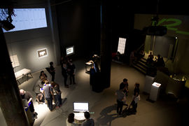
The exhibition space
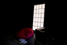
The set up
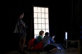
The set up + people inside


The results I got were extremely variable from one person to another, underlining the difficult aspect of drawing a line between the two notions. The mental representation we have of what is natural and what is technological can conflict with the actual traces of human involvement to generate those representations.

Cyan is the highest score (technology)
Green is the smallest (nature)
Yellow is the average (final position)
I asked for names and biographies because I thought that it would directly relate to the subjectivity in answers provided (a graphic designer and a nurse may not share the same view over what nature may look like, due to their education and activities)
I also specified that I wanted the sheets to be filled by hand to keep the trace of human labour involved.


Thesis intention
I would like the thesis to reflect on my process. Making an installation within a networked environment necessitates to be mediated by means for spatial representation. Since the tools for mediation plays a major part within the work, I will reflect on their implications and functioning. I think it will be also important to define to which extent, how and why things can be physically located through digital networks. The spatial properties of the Internet determine our relation to society. They define what it means to inhabit Earth in the era of ubiquitous computer networks. The context part is already underlining a few notions I am interested in.
Context
“Our culture is undergoing a truly drastic change in terms of our physical and psychological relationship with space and other bodies.”
-Machiko Kusahara [6]
1. Entropy

"The future is but the obsolete in reverse"
-Vladimir Nabokov [7]
[…] it's (entropy) a condition that's irreversible, it's condition that's moving towards a gradual equilibrium and it's suggested in many ways.
-Robert Smithson[8]
Following the logic described by Smithson's drawings about the Earth works, my site installation will perish, because of changes in the network. This equilibrium mentioned by Smithson is nested within the continuity experienced by users while browsing experience of the Internet, as discussed by Alexander R. Galloway.[9] Continuity is enhanced through a strict set of rules, contributing to erase any trace of obsolescence from the user's experience (link rot, obsolete machines, etc). The failure to maintain the work on a long time scale can reveal the rapid changes in agencies within digital networks. It is also an act of resistance against the sensation of smooth continuity enhanced by protocols. This notion is also present in the recently unveiled A quiet desert failure[10] by Guido Segni which automates the transfer of Google's satellite images from the Sahara desert to Tumblr's data servers. The page mentions that “The whole performance will approximately take 50 years to be completed, but it is still not clear if the audience, the Google’s servers, the Tumblr archive or the Internet itself will last enough to see the end.”
Drawing a static shape over the Internet would constitute an event that will become quickly impossible to reenact. The reasons for its failure are nested within the administration of such space.
2. Contexts of appearance

"Instead of putting something on the landscape, I decided it would be interesting to transfer the land indoors, to the Non-site, which is an abstract container."
-Robert Smithson [11]
Since the installation is happening within the Internet's invisible infrastructure ( a network of digital networks), the work has to manifest within another format than its actual site. I will need to find a way to translate of the spatial dimension of the piece. The margin for variability that I like to allow within my projects is something that makes me relate a lot to Robert Smithson. In the case of Spiral Jetty (1970) for instance, Smithson considered that the work had three manifestations under the same name, and that each of them constitutes a work in its own right. Those consist in the outdoor installation at Rozel point in the Great Salt Lake (Utah)[12], the film[13] and an essay[14]. To Smithson, the sculpture was occupying a Site, while the film and the essay constituted non-sites. Language (the essay), photographic images (the film), and earth (the jetty) were considered by Smithson as materials of equal values. This approach is certainly informed by the aforementioned notions of entropy but also due to the intentions behind the site intervention. The work is processual, on an environmental scale , and in a remote location. The idea of the piece has to manifest in a shape that is appropriate to the context in which it is being communicated about. The different formats used can contrast with each other in terms of their capacity to endure time and space. Similarly, a digital network intervention can re-manifest itself within different strategies to communicate about its intentions. Moreover, my work cannot be experienced at all, so the only proof that the configuration I will show exist will be visible within the documents.
3. Inhabiting maps

Relating IP addresses over the Network with Earth's physical position means that I have to deal with the geographic coordinates system. This system needs knowledge of geographic cartography for decoding, since they are in a dialogue (plotted map and attributed points). It will be a necessary evil/interface for me. Geert Lovink says that “Richard Rogers suggests that mapping networks, especially as an intelligence task, carries with it more than just an aesthetic outcome; we are in the midst of a techno-pistemological impulse in which the form(at) of the map has a structuring effect on how we understand the organisation (structure) and dynamics (movement) of networks (2003).” I think that this does not apply to networks only, but to the old tradition of geographic cartography as well, although mapping digital networks has a shorter history. People have an impression of the rest of the world that they acquired through maps. If I didn't go around the world with a mental idea of the European frontiers, within which France happens to be located, I would never be able to identify myself as a European person. Ideological content gets assigned to places through maps as they create spatial relations between groups of populations. We inhabit them as a result. As Martin Dodge puts it: All world maps are semiotically frontier signs, on the ground, the frontier line is not physically traceable yet maps have a performative action in the construction of territory
All maps are untrue by essence, because they cannot represent all the things of the world (unless they were on the scale of a mile for a mile [15]). Nevertheless, I think that the physical and the digital should be associated in spatial representations, since their association constitutes the social environment. I am not sure yet if I would restrain myself to the typical Mercator projection for the outcome of the project, but I will certainly need it through the process. The plotting on such model draws from the “known” and goes beyond. Doing so can provoke positive responses[16] like the ones provoked by Silvio Larusso's Data Centre Grand Tour[17]. Also, since I am not trying to reveal any type of truth about networks behaviour, I hope that I can at least show that any story can be told when it comes to mapping.
4. Finding patterns in the Sky
Finding patterns in the sky has been a long-going practice in the history of human civilizations. Drawing shapes with stars has enabled people to have a stable geolocating system in relation to which they could navigate, cultivate food, keep track of time and support mythological belief (religion, astrology etc). Discovered in 2004, a structure called the Temple of Fox (2000BC), in Buena Vista (Peru) has established the use of constellations and astronomy by the Andeans as a guide for agriculture.[18] The urban planing of the Mayan cities, the orientation of the Giza pyramids in Egypt or the traditional Polynesian navigation methods[19] are other examples (out of many) which establish the use of stars to define systems for positioning. In a much less distant past, celestial navigation was used extensively in aviation and marine navigation. Due to the fear of G.P.S system hacking, the U.S army has decided this year to return to this method. It has eventually stopped being part of the training about two decades ago. [20] This method shows many advantages, also for the military purposes : it can be used independently of ground aids, it has global coverage, it cannot be jammed (only clouds can be a problem) and does not give off any signals that could be detected by an enemy.
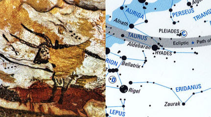
[[1]] "The map, which is thought to date back 16,500 years, shows three bright stars known today as the Summer Triangle."
[[2]]Dunhuang Star map circa 710]]
[[3]] Ancient Egyptian star chart and decanal clock on the ceiling from the tomb of Senenmut circa 1473 B.C.


What the multiplicity and applications of constellation maps show is that all human civilizations have needed the support of these patterns for order to emerge out of chaos. I feel that the metaphorical association of star constellations is therefore a lot more tangible for imagining computer networks than the current obfuscating clouds and oceans. It is not a merely playful act, projecting ones imagination onto the distant enables people to inhabit their local environment.
5. About Human Ressource Management


"Territory is not given, but constituted, and this constitution is likewise the organization of the individuals in it."
Baudrillard
One of the many reasons of my interest for the Environmental movement of the 60s is that it was very much concerned with the way in which we inhabit society and construct our perception of space. In a text published in Artforum in April 1977, Nancy Holt reflects on the process of making the Sun Tunnels. [21] “In making the arrangements and contracting out the work, I became more extended into the world than I’ve ever been before.”, she wrote. This made me think that drawing with IP addresses over the Earth is not just my own personal enterprise. It puts me in relation with a lot of places, and people involved with the regulation of the Internet as the space it is. By creating such type of work, one acts from their direct environment and draws new configurations for encounters between people. With Networks, these relations morph into new shapes, which are determined by the ability for one individual to reach another. This notion is greatly present in re-projecting by Ricardo Basbaum commissioned by the Showroom in 2013 [22] The project unfolds as nine interventions, each connecting with nine locations determined by the application of an abstract shape onto the map of the area around the gallery. The shape, which Basbaum calls NBP (New Basis for Personality), has formed the basis of numerous works in diverse formats since the early 1990s, providing a situation that others are invited to take over and shape. Basbaum’s NBP shape creates a framework for individuals and groups to connect [...] [23]
Perhaps the work should be appreciated as an apparatus, following the definition given by Giorgio Agamben.
“I will call an apparatus, literally anything that has in some way the capacity to capture, orient, determine, intercept, model, control, or secure the gestures, behaviors, opinions, or discourses of living beings."
-Giorgio Agamben
As a consequence, mapping space and delineating shapes over Earth provokes a re-agency of human activity on a particular set of conditions and over a huge scale. To me, nothing is more tangible than understanding that something is physically somewhere in relation to us.
Practical steps
I am using a MongoDB version of the MaxMind GeoIP legacy database[24]. It is a free version of a bigger commercial database, used against fraud and for targeted advertisement. This database lists allocated IP addresses alongside its geographical information such as the country, city, longitude and latitude. I have exported some json files compiling data on Latitude and Longitude requests. I am currently using OpenStreetMap and Leaflet for the mapping because it is easy to get some quick representation.[25]
After Christmas, I'll need to make more complex requests, such as precise geometrical shapes to my actual stars constellations. Then I will be able to work on prototypes for displaying the information. I am very open regarding the format, as I will have to see that in time with the generated content (video, images or text). Also, the format has to be in adequation with the research. For instance, the database I use is presented as a tool against fraud and for targeting adverts. This surely has to be taken into account.
Alongside the practical developments, my project has to be informed by other parameters. Who are the people behind Maxmind? How can they claim 99% accuracy and how is the checking operated? How much manual labour is involved? I have already tried to get a bit of information when I wrote a text on GeoIP databases, but perhaps getting in touch or envisioning a way to let them know about my work would be nice. I like to exchange with others when I work and having these types of logs is valuable to me.
Regarding the documentation of my references and process, I will stick to the tools I have developed over the last year. Firstly, I have adapted the interface of a very simple cms which I can update it from my computer over my server thanks to Git. It functions as a notebook which helps me keep a trace of what I have been reading. It is quite flexible and I try to add pads next to my notes in case I ever want to cross references.
→ http://pzi.here-you-are.com/notebook/ .
I have prepared the same system to have a set of images I can refer to
→ http://pzi.here-you-are.com/imgdir/
Sometimes, when investigating a specific topic, I also write a text as it helps me assimilate information that I have been gathering and and associate facts together. This practice often goes alongside making practical sketching experiments such as the following ones :


https://pzwiki.wdka.nl/mediadesign/User:Jules/opticsofdatatransmission


https://pzwiki.wdka.nl/mediadesign/User:Jules/wifiheatmap


http://pzwiki.wdka.nl/mediadesign/User:Jules/geoipdatabases
References
1. Artworks
- Sun Tunnels – Nancy Holt, 1976 (human management over land, information transfer)
- Would you like to participate in an Artistic experience – Ricardo Basbaum, 1994-ongoing (human management over land)
- How and where to draw the circle? – Ian Wilson, 1968 (politics of spatial delineation)
- When Faith Moves Mountains – Francis Alys, 2002 (Human management)
- Gallery Transplants – Dennis Oppenheim, 1968 (data transfer, entropy)
- A quiet desert failure, Guido Segni – 2013-ongoing (Digital Entropy)
- Spiral Jetty – Robert Smithson, 1972 (variability)
- Spiral Jetty in Minecraft – Jan Robert Leegte, 2013 (contextual reactivation)
- Vertical Earth kilometer – Walter de Maria, 1977 (The title is the Non-site)
- Socle du monde – Piero Manzoni, 1961 (map imprinted in the brain)
- The california Map Project – John Baldessari, 1973 (inhabiting the map)
- Map – Aram Bartholl, 2010-? (inhabiting the map)
- Data centre Grand Tour – Silvio Larusso, 2012 (mapping creates a new reality - quote)
2. Bibliography
- Imagining Internet Infrastructures: Spatial Metaphors and Scientific Inscription (Understanding Cyberspace Cartographies: A Critical Analysis of Internet Infrastructure Mapping, chap 4 ), Martin Dodge, 2008
- IP Geolocation Databases: Unreliable?, 2011, Ingmar Poese, Steve Uhlig, Benoit Donnet, Mohamed Ali Kaafar, Bamba Guey
- Atlas of cyberspace, Martin Dodge, 2001
- Entropy and the new monuments, Robert Smithson, 1966
- Steps to an ecology of the mind, 1972 Gregory Bateson
- A cyborg manifesto, 1983 Donna Haraway
- On exactitude in science, Jorge Luis Borges, 1946
- Anti Oedipe, Deleuze and Guattari, 1972
- What is an apparatus? Giorgio Agamben, 2009
- Theses on distributed aesthetics or what a Network isn't, Anna Munster & Geert Lovink, 2005
- Protocols or how control exists after decentralization, Alexander R. Galloway, 2004
- The Internet Revolution: From Dot-com Capitalism to Cybernetic Communism, Richard Barbrook and Andy Cameron, 1995-1999
- Mother Earth Mother Board, Neal Stephenson, 1996
- From weak ties to organized Networks, Ideas, Reports, Critiques,Inc, 2009
- E flux journal, the Internet does not exist, 2015
3. Links
https://artforum.com/inprint/issue=197704&id=35992
https://en.wikipedia.org/wiki/Satellite_map_images_with_missing_or_unclear_data
http://www.fastcodesign.com/1671946/see-where-websites-live
http://www.theguardian.com/artanddesign/2015/feb/04/google-data-farm-john-gerrard-internet-art
4. Extensive listing
For actual set of references, or just things that trigger my interest, please see:
http://pzi.here-you-are.com/notebook/
The notebook contains etherpads on which anyone can add thoughts or references they feel like doing such
http://pzi.here-you-are.com/imgdir/
- ↑ (1)Lisa Bear et Willoughby Sharp, "Discussions with Heizer, Oppenheim, Smithson (1970)", In : Robert Smithson : The Collected Writings, Berkeley, Los Angeles, London, University of California Press, 1996, p. 244.
- ↑ https://pzwiki.wdka.nl/mediadesign/User:Jules/linkingdots
- ↑ http://pzwiki.wdka.nl/mediadesign/User:Jules/browsedlandscapes
- ↑ http://userasanendpointofsomediameter.com/
- ↑ http://pzwiki.wdka.nl/mediadesign/User:Jules/remindsmeofinterstellar
- ↑ “Presence, Absence, and Knowledge in Telerobotic Art,” in The Robot in the Garden, 2000
- ↑ "Lance", 1952
- ↑ "Entropy made visible", 1973
- ↑ "Protocols or how control exists after decentralization", 2004, p 68
“All technology is new technology. Everything else must be eliminated. Dead media are those media that have fallen out of use. They include everything from dead hardware (Commodore 64, Apple II) to dead computer languages (Fortran, Cobol) to dead media formats (Sony Betamax, 8-track cassette). Dead media means discontinuity. Dead media do not function within contemporary network flows; therefore, they have no place.” - ↑ http://desert.fail/ure/
- ↑ (Kasther and Wallis, 1998: 31)
- ↑ http://www.robertsmithson.com/earthworks/spiral_jetty.htm
- ↑ https://www.youtube.com/watch?v=vCfm95GyZt4
- ↑ The Spiral Jetty, 1970, published in Robert Smithson: The Collected Writings, edited by Nancy Holt, New York University Press, pp. 109-113
- ↑ "On the exactitude in sciences" Jorge Luis Borges, 1946
- ↑ "Seeing the entire exhibition takes all of 30 seconds if you click quickly, but it will inevitably leave your perspective changed. Because even though we all know that the Internet spans the world, our browsers render it as an experience all of 13 inches wide on a laptop screen, with no image, video, or article more than a few keystrokes or clicks away. Our feedback for this exploration is wholly positive in nature—we’re constantly rewarded with content at no real cost, like children who understand the concept of money but have absolutely no concern as to how their parents make it." Mark Wilson
http://www.fastcodesign.com/1671946/see-where-websites-live - ↑ https://www.youtube.com/watch?v=3YSWXHUAG4A
- ↑ http://phys.org/news/2006-05-oldest-art-agriculture-calendar-world.html#jCp
- ↑ https://en.wikipedia.org/wiki/Polynesian_navigation
- ↑ http://www.military.com/daily-news/2015/10/14/celestial-navigation-returns-to-naval-academy.html
- ↑ In 1974 she bought a piece of land in the Great Basin Desert, Utah, where she decided to build her piece. She described that the site installation and the documentation of the process, required the help of “2 engineers, 1 astrophysicist, 1 astronomer, 1 surveyor and his assistant, 1 road grader, 2 dump truck operators, 1 carpenter, 3 ditch diggers, 1 concrete mixing truck operator, 1 concrete foreman, 10 concrete pipe company workers, 2 core-drillers, 4 truck drivers, 1 crane operator, 1 rigger, 2 cameramen, 2 soundmen, 1 helicopter pilot, and 4 photography lab workers.”
- ↑ http://www.theshowroom.org/exhibitions/ricardo-basbaum
- ↑ http://www.e-flux.com/announcements/ricardo-basbaum-2/
- ↑ https://www.maxmind.com/en/home
- ↑ http://pzwart1.wdka.hro.nl/~jules/plottingOSM/indexlng3.html