
User:Jules/graduationproposal: Difference between revisions
No edit summary |
|||
| Line 25: | Line 25: | ||
==Relation to previous practice== | ==Relation to previous practice== | ||
My previous practice is articulated around the process of mapping space and questioning the ways of creating such visualisations | My previous practice is articulated around the process of mapping space and revealing invisible processes but also questioning the ways of creating such visualisations. The reflexivity on the tools is important to me because visualisations are performative and can determine our relationship to our close and distant environment. Another important thing about my work is that I never really consider my projects as formally set. I feel that they allow enough flexibility to allow different modes of presentation. | ||
=== 1. Browsed landscapes <ref>http://pzwiki.wdka.nl/mediadesign/User:Jules/browsedlandscapes</ref> === | === 1. Browsed landscapes <ref>http://pzwiki.wdka.nl/mediadesign/User:Jules/browsedlandscapes</ref> === | ||
Revision as of 00:14, 16 November 2015
~(^=^~)
Introduction
My graduation project would consist in performing drawings over the world with IP addresses on the basis of their geographical coordinates. Formally, this project was inspired by the Gallery Transplants made by Dennis Oppenheim in 1969. A Gallery Transplant consists in a transfer from the enclosed architectural and cultural space of the museum to an open exterior space. He applied the process to the Andrew Dickson White Museum and the Stedelijk Museum transferred respectively to the campus grounds of Cornwell University and Jersey city.


The plan of the galley's floor is drawn outside in the snow. The result is then presented with an official plan of the Gallery, a topographic map and a picture of the installation.
Robert Smithson referred to that work talking about “Dis-location” to qualify Oppenheim's process. To him Oppenheim operated in a Data transfert from a part of the world to another.[1]
Following the same logic as the Earth works, the execution of my project would be twofold. I would first perform the drawings, connecting points until the whole figure breaks down because of changes in the Network. Smithson described entropy as a condition that's irreversible, moving towards a gradual equilibrium.[2] This equilibrium consists in the continuity in the browsing experience of the Internet by its users, as discussed by Alexander R. Galloway in the chapter about Form of digital Networks in Protocols or how control exists after decentralization [3]
Thinking about the sun tunnels of Nancy Holt made me consider the mapping of star constellations, as an analogy with computer Network topologies and a nod towards celestial navigation.
"It’s an inversion of the sky/ground relationship-bringing the sky down to the earth."
As an apparatus, the Sun Tunnels enables the connection between the two milieus by transferring information from one to the other.
Relation to previous practice
My previous practice is articulated around the process of mapping space and revealing invisible processes but also questioning the ways of creating such visualisations. The reflexivity on the tools is important to me because visualisations are performative and can determine our relationship to our close and distant environment. Another important thing about my work is that I never really consider my projects as formally set. I feel that they allow enough flexibility to allow different modes of presentation.
1. Browsed landscapes [4]
Browsed landscapes consists in a series of three projects like variations of the same process The different applications of the same operation can generate different highlights over the question of the place when it comes to the Internet's infrastructure outputs. The investigation was pursued over the Network with the tools I could find.


Demo on Max OS X using Google Chrome Browser
2. Userasanendpointofsomediameter [5]
With userasanenpointofsomediameter, I geolocated the user's position on Google maps and took him through a “fake tunnel” that would lead them to the antipodes of their position. Although the title suggests the World as a spherical geometrical shape, the whole process deploys itself over the flat surface of the screen. This paradox is also present within the tool used, the ubiquitous interface of Google maps is presenting to us a flattened vision of the world.


Nevertheless, within the API, I used the formula enabling to find a diameter's endpoint, in relation to any point over a circle's circumference.
var antipodes_lat = currentLatLng.lat() * -1;
var antipodes_lng = currentLatLng.lng() + 180;

3. It reminds me of a scene in Interstellar [6]
For the project “It reminds me if a scene in Interstellar”, I established a set of 25 videos that I found on youtube and which, to my opinion, could be ambiguous. The audio and titles were removed, to only focus on the visual content, outside its primary context. I wanted to have a certain amount to encourage people to not over think about them but give quite spontaneous opinions. Then, a panel of 17 volunteers have been asked to rate a set of 25 video extracts of 15 seconds each. The rating has been established on a scale from 1 to 10, where 1 corresponds to nature and 10 to technology. Sometimes, the volunteers explained the motivation behind the decisions they made. The average grades defined the positioning of the videos in the final montage. The result functions as a gradient, from one idea to the other.
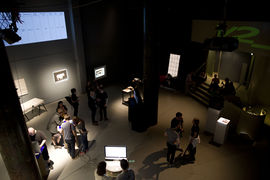
The exhibition space
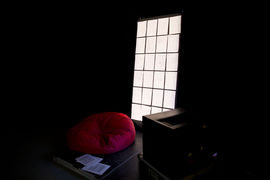
The set up
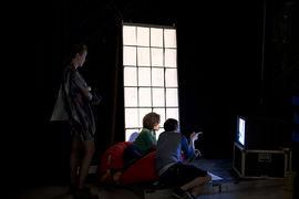
The set up + people inside


The results I got were extremely variable from one person to another, underlining the difficult aspect of drawing a line between the two notions. The mental representation we have of what is natural and what is technological can conflict with the actual traces of human involvement to generate those representations.

Cyan is the highest score (technology)
Green is the smallest (nature)
Yellow is the average (final position)
I asked for names and biographies because I thought that it would directly relate to the subjectivity in answers provided (a graphic designer and a nurse may not share the same view over what nature may look like, due to their education and activities)
I also specified that I wanted the sheets to be filled by hand to keep the trace of human labour involved.


Context
- Orientation/ Navigation is twofold
-> A static/abstract system to organize space within a grid
-> A subject moving in respect to that system
-> We see less and less the access points and wires enabling telecommunication. Humans are moving around with their devices, the grid of reference becomes the idea of the map since the urban environment didn't evolve so much.
- Modes of capturing the scale of what cannot be seen directly
-> The depicted figure is not part of the direct realm but of a mediated landscape


- Map precedes Territory

"Socle du monde. Socle magique n°3 de Piero Manzoni. 1961. Hommage à Galilée"
The work implies some pre requisites :
- By 1961 there was a common agreement that the Earth is "spherical", it is possible to reverse it from any point. It deals with the expectations imposed on us by Earth gravity.
- Knowing the very purpose of a "socle" for, we allocate a supporting function to the object and combine it to the Earth to mentally finish it.
- The socle is part of a series entitled "socles magiques". On the previous ones it was possible to climb on a socle be signed by the artist and become a work of Art (which relates a bit more to what can be authentificated/recognized as being Art)
Therefore the work's logic is nested in Linguistic system as it is impossible to see it in its globality without "thinking abstractly".
Thesis intention
I would like the thesis to reflect on my process. I often try to investigate the implications and functioning of the tools I use. By doing so, they become narrative device and get re associated with the intentions of their creators and propagators. I think it will be also important to define what it means to locate and mediate physical locations through Digital Networks.
Practical steps
At the moment, I am getting more familiar with the tools. I am using a MongoDB version of the MaxMind GeoIP legacy database. I have exported some json files compiling all the relevant data on Latitude and Longitude criteria. I need to make more complex requests soon, such as precise geometrical shapes, and start experimenting with the plotting. I may start visualising the locations with Google Maps for a first draft but I would like to be able to cross with other types of maps.
After Christmas, I will work on using IP addresses extracted on the basis of Geographic criteria to find websites, so I could spatially recontextualise information and location.
Then I will be able to work on prototypes showing information alongside location.
Regarding the documentation of my working process, I will try to build on the things I have developed over the last year.
Firstly, I have adapted the interface of a very simple cms which I can update it from my computer over my server thanks to Git. It functions as a notebook which helps me keep a trace of what I have been reading. It is quite flexible and I try to add pads next to my notes in case I ever want to cross references.
→ http://pzi.here-you-are.com/notebook/ .
I have prepared the same system to have a set of images I can refer to (although I have been very bad at updating it so far).
→ http://pzi.here-you-are.com/imgdir/
Sometimes, when investigating a specific topic, I also write a text as it helps me assimilate information that I have been gathering and and associate facts together. This practice often goes alongside making practical sketching experiments such as the following ones :


https://pzwiki.wdka.nl/mediadesign/User:Jules/opticsofdatatransmission


https://pzwiki.wdka.nl/mediadesign/User:Jules/wifiheatmap


http://pzwiki.wdka.nl/mediadesign/User:Jules/geoipdatabases
References
- Simulacra and simulation, 1994, Baudrillard
Today abstraction is no longer that of the map, the double, the mirror, or the concept. Simulation is no longer that of a territory, a referential being or substance. It is the generation by models of a real without origin or reality: A hyperreal. The territory no longer precedes the map, nor does it survive it. It is nevertheless the map that precedes the territory - precession of simulacra - that engenders the territory.
- Steps to an ecology of the mind, 1972 Gregory Bateson:
We say the map is different from the territory. But what is the territory? Operationally, somebody went out with a retina or a measuring stick and made representations which were then put on paper. What is on the paper map is a representation of what was in the retinal representation of the man who made the map; and as you push the question back, what you find is an infinite regress, an infinite series of maps. The territory never gets in at all. The territory is Ding an sich and you can't do anything with it. Always, the process of representation will filter it out so that the mental world is only maps of maps, ad infinitum.
- Flat Earth Society
- From Psychogeography to Cybertopology; 2006, Sher Doruff
(dis)Orienting Place : Performing “ place” through purposeful disorientation was the aesthetic of early Situationist dérives. Today the technological accoutrement for triangulated, coordinate spe-cific, Cartesian orientation is apparent in many current locative projects. Aesthetic practice accessed through a network of military satellites has détourned the dérive signifi-cantly. The shapeshift between discipline and control, between game and play, is felt in the relation between orientation and disorientation.
- Smooth and striated space, 1972, A thousand plateaux
- Entropy made visible, 1973, Robert Smithson
De-architecture : Architects never seem to allow for any kind of relationship outside their own plans, same with economics. They expect to be isolated and self-contained, conceived as cycles to exclude the entropic process.
- Martin Dodge, 2008
- GPS Errors and Pilgrimage to Lourde, 2010, Benjamin Mako Hill
http://revealingerrors.com/lourdes_gps
———??? “Architecture is an art of distinctions within the continuum of space.” (W.J. Mitchell, The Logic of Architecture, p.1)
- ↑ (1)Lisa Bear et Willoughby Sharp, "Discussions with Heizer, Oppenheim, Smithson (1970)", In : Robert Smithson : The Collected Writings, Berkeley, Los Angeles, London, University of California Press, 1996, p. 244.
- ↑ Entropy made visible, 1973
- ↑ 2004, p 68 “All technology is new technology. Everything else must be eliminated. Dead media are those media that have fallen out of use. They include everything from dead hardware (Commodore 64, Apple II) to dead computer languages (Fortran, Cobol) to dead media formats (Sony Betamax, 8-track cassette). Dead media means discontinuity. Dead media do not function within contemporary network flows; therefore, they have no place.”
- ↑ http://pzwiki.wdka.nl/mediadesign/User:Jules/browsedlandscapes
- ↑ http://userasanendpointofsomediameter.com/
- ↑ http://pzwiki.wdka.nl/mediadesign/User:Jules/remindsmeofinterstellar